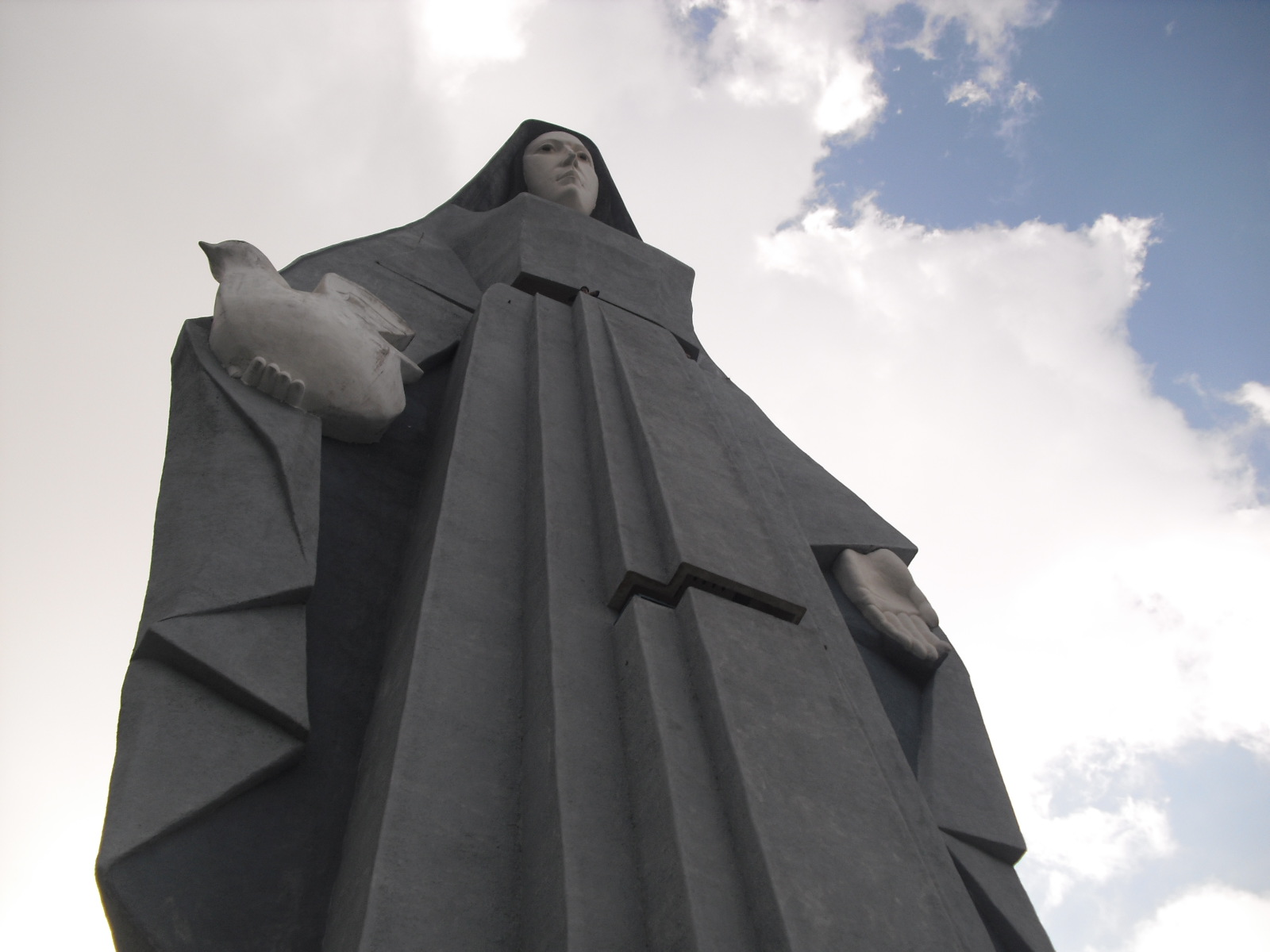
The Venezuelan Andes don't end in Mérida. In Trujillo stands the Teta de Niquitao-Guirigay natural monument, the highest mountain in the state, at 4,006 meters, and 11 kilometers southwest of the city of Trujillo rises the Monument to the Virgin of Peace (Monumento a la Virgen de la Paz), 46.72 meters tall. Táchira, on the border with Colombia, is a natural passage between the Mérida Andes and the Eastern Cordillera of Colombia, and there El Tamá National Park protects 139,000 hectares between Táchira and Apure. Here you'll find the guides for those two states. For Mérida state, go to the Mérida page. Before you visit a park or the border area, check access and permits with the authorities.
What the Andes of Trujillo and Táchira are and where they are
Trujillo and Táchira are the two Andean states on either side of Mérida: Trujillo to the north, with páramos (high Andean moorland) and a famous monument, and Táchira to the southwest, on the border with Colombia. For Mérida state, which has its own guide, go to the Mérida page. This page covers everything outside it.
Trujillo has a city founded in the 16th century. According to Wikipedia, the city of Trujillo was founded in 1557 and relocated on October 27, 1570. The state brings together mountains, colonial towns and a historic highway: the Trasandina highway, opened in 1925, runs across the region.
Táchira, for its part, is a natural passage between the Mérida Andes and the Eastern Cordillera of Colombia, with a capital, San Cristóbal, and several mountain towns. It's a border area, so any plan that takes you close to the border should include checking access and permits with the authorities.
How to get to Trujillo and Táchira from Caracas and Valencia
You get there by road, on buses to Valera, Trujillo or San Cristóbal. We didn't find a public source with current travel times or distances from Caracas or Valencia to these states, so confirm them with the bus company or the airline before you leave.
Within Trujillo, the Trasandina highway links the mountain towns, and from the city of Trujillo you can reach the Virgen de la Paz monument, which according to Wikipedia is 11 kilometers southwest of the city. The state's most populated cities, such as Valera, connect it with the rest of the country. In Táchira, San Cristóbal is the usual starting point for El Tamá, La Grita and the páramo villages.
Mountain roads can get foggy and see landslides in the rainy season. It's best to travel by day, check road conditions on the day and fill up the tank before you head up.
How much a trip through Trujillo and Táchira costs
We didn't find dated public prices for transportation, admission or lodging in these states, so every amount needs to be confirmed before you travel. Instead of making up figures, here are the items worth getting in writing:
- Round-trip fare to Valera, Trujillo or San Cristóbal.
- Local transfers between towns and out to the viewpoints.
- Admission or permits for national parks or natural monuments, through Inparques.
- A guide for hikes to the páramos or to Teta de Niquitao.
- Lodging per night, and whether breakfast is included.
Best time to go and weather
Temperatures change a lot with altitude, and it's cold on the páramos all year. Wikipedia notes that in Trujillo's mountain areas the climate ranges from about 6 to 20 °C. In Táchira, San Cristóbal has an average daytime temperature of 24 °C and a nighttime average of 18 °C, milder than the páramo.
We don't have a source that sets an official dry season for these areas. As a rule of thumb, clear views are more likely outside the rainiest months, but mountain weather changes in minutes: bring a rain jacket and layers whenever you go.
Things to do and see in Trujillo
Trujillo's symbol is the Virgen de la Paz monument, and its highest natural point is Teta de Niquitao. About the monument, Wikipedia reports that it was unveiled on December 21, 1993, stands 46.72 meters tall and has five viewing platforms looking out over Lake Maracaibo. The summit of Teta de Niquitao-Guirigay, a natural monument, reaches 4,006 meters, making it the highest mountain in the state.
Other places Wikipedia mentions in the state:
- Boconó: a mountain town on the Andean route.
- Isnotú: home to the chapel dedicated to José Gregorio Hernández.
- La Puerta: where you will find Castillo San Isidro.
- Valera: the most populated city in the state.
- Páramo El Corazón, in the El Riecito park and protected area: a páramo route for hikers who go with a guide.
- Niquitao: site of the battle of July 2, 1813, according to Wikipedia.
Things to do and see in Táchira
Táchira combines mountain towns, páramos and a national park on the border. San Cristóbal is the capital and, according to Wikipedia, was founded on March 31, 1561. Nearby are La Grita, founded in 1576, and the El Zumbador, Los Rosales and La Negra páramos.
The big natural draw is El Tamá. Wikipedia notes that El Tamá National Park protects 139,000 hectares, was created on December 12, 1978, and has a páramo at 3,320 meters and Cerro El Cobre, at 3,613 meters. Because it sits on the border, check access and permits with Inparques and the authorities before you go. There are also towns with a character all their own, such as Peribeca, San Pedro del Río, El Cobre and Pregonero, plus Chorro El Indio National Park.
Where to stay
The most practical bases are the main cities: Trujillo or Valera for Trujillo state, and San Cristóbal for Táchira. From there you can take day trips to the viewpoints, towns and páramos. If you're planning a multi-day hike, sleep in the town closest to the trailhead.
We don't name guesthouses or give prices because we don't have a current public source. Browse Mapitt's pages for Trujillo and Táchira and confirm availability with your host. During festivals and holidays, book well ahead.
Tips and safety
The first thing is to keep mountain travel and border travel apart. For páramos, parks and viewpoints, bring warm clothes, water and shoes with good grip, and tell someone your route. For any area near Colombia, such as El Tamá, check access conditions and the current permits beforehand.
Travel by day in the mountains, avoid driving in fog and don't leave valuables in sight in your car. Carry cash in small bills for remote towns and make sure your ID hasn't expired. If you plan to combine this trip with the peaks of Mérida, start with the lower spots so you can acclimatize.
Guides for your trip
- Mérida and the Venezuelan Andes: what to do beyond the cable car: From the cable car to Pico Espejo (4,765 m) to páramo villages and high-altitude lakes: how to get there, when to go and dated fares.
- Mérida cable car: prices, hours and how to get there: Dated Mérida cable car fares, status after the August 2026 reopening, last rides up by station, how to get there and what to see up high.
Táchira
Trujillo
Frequently asked questions about Andes: Trujillo and Táchira
Teta de Niquitao-Guirigay, a natural monument that reaches 4,006 meters, according to Wikipedia. It is the highest summit in Trujillo state.
It stands 46.72 meters tall, according to Wikipedia, and is about 11 kilometers southwest of the city of Trujillo. It has five viewing platforms looking out over Lake Maracaibo.
San Cristóbal, mountain towns such as La Grita or Peribeca, the El Zumbador páramos and El Tamá National Park. Since it is a border area, check access and permits beforehand.
On the border with Colombia, between Táchira and Apure, and it protects 139,000 hectares, according to Wikipedia. Access needs to be confirmed with Inparques and the authorities.
By road, on buses to Valera or Trujillo. We don't have a public source with current travel times, so confirm them with the bus company.
Mérida has the highest summits, such as Pico Bolívar, plus the cable car, and has its own guide on Mapitt. Trujillo and Táchira offer other páramos, monuments and towns, which this page sums up.
Do you run a guesthouse or offer tours in the Andes?
List your stay or experience for free on Mapitt and reach people planning to visit the Andes.
Information checked on November 10, 2026 at: Wikipedia (Spanish): Monumento natural Teta de Niquitao-Guirigay; Wikipedia (Spanish): Monumento a la Virgen de la Paz; Wikipedia (Spanish): Estado Táchira; Wikipedia (Spanish): Parque nacional El Tamá; Wikipedia (Spanish): Estado Trujillo.
How we build this list: Places in Trujillo or Táchira state, grouped by state. Only places with complete pages make it in.